Hiking Big Bend National Park by Laurence Parent & Globe Pequot Press
Author:Laurence Parent & Globe Pequot Press
Language: eng
Format: epub
Tags: FalconGuides, day hikes, hiking, hikes, hiking trails, day hikes, wilderness, national forest, national parks, wildlife, nature
Publisher: Falcon Guides
Published: 2013-10-17T04:00:00+00:00
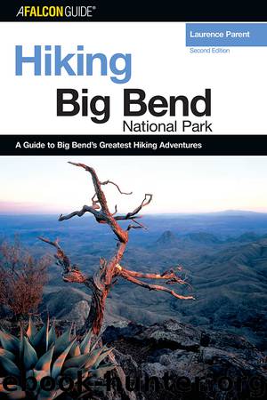
Sheer cliffs drop more than 1,000 feet from the Mariscal Canyon Rim to the Rio Grande.
The easy first 1.5 miles of this hike parallel the river on a bench above the floodplain. The route travels across colorful shales and siltstones of the Pen Formation, which are penetrated by various intrusions of darker igneous rocks. In their geologic past, some of the sedimentary layers were “baked” by the igneous activity, adding to their color. Crystalline veins streak through the fractured rocks, and unique nodules and concretions litter the area. Even the rock cairns marking the first 1 mile of this route contain a mixture of rocks that mirror the geologic diversity of this area.
The sparse vegetation along this part of the route helps make travel here easy. Apparently the shales, marls, mudstones, and other rocks of the Pen Formation, combined with low precipitation levels, provide a poor environment for plant growth. Here, the desert contains only spotty examples of ocotillo, prickly pear, creosote, stunted whitethorn acacia, and Mexican rubber plant or guayule.
After the first 1.5 miles, the trail enters and follows a dry wash. It is along this stretch that the Pen Formation gives way to thin-bedded, chalky gray limestones and shales of the Boquillas Formation. After leaving the drainage, the trail begins a moderately strenuous climb toward cliffs along the ridge of Mariscal Mountain and the canyon itself.
As the trail climbs higher, many cacti become evident, including Texas rainbow, eagle’s claw, and pincushion varieties. One cactus, the silverspine cane cholla, is a variety of cane cholla endemic to the dry slopes of Mariscal Mountain and grows naturally nowhere else on Earth.
As you climb, look west; the meandering floodplain of the Rio Grande looks like a narrow green oasis sprawling across the vast Chihuahuan Desert landscape. To the north, the eroded geologic layers alongside Mariscal Mountain’s anticlinal fold have created an impressive series of hogbacks. The uppermost of these scalloped-looking ridges, closest to the massive limestone walls of Mariscal Mountain, is capped by the Del Rio Clay Formation.
At the base of the cliffs the trail momentarily levels off. If you are backpacking, this level terrace makes for a pleasant campsite. From here, the trail cuts sharply to the left and switchbacks up to the top of Mariscal Mountain. The next 0.25 mile is the most strenuous part of the hike; it gains another 400 feet as it switchbacks through the massive Santa Elena limestone cliffs of Mariscal Mountain. Once on top, however, the trail levels off and generally parallels the canyon several hundred yards back from the rim. At almost any point once the trail levels off, select your own route and work your way over to the precipitous rim. The vertigo-inducing overlooks are magnificent.
Download
This site does not store any files on its server. We only index and link to content provided by other sites. Please contact the content providers to delete copyright contents if any and email us, we'll remove relevant links or contents immediately.
Periodization Training for Sports by Tudor Bompa(8335)
Bodyweight Strength Training by Jay Cardiello(7971)
Therapeutic Modalities for Musculoskeletal Injuries, 4E by Craig R. Denegar & Ethan Saliba & Susan Saliba(7747)
Born to Run: by Christopher McDougall(7169)
Imperfect by Sanjay Manjrekar(5907)
Wiseguy by Nicholas Pileggi(5844)
Shoe Dog by Phil Knight(5328)
Paper Towns by Green John(5248)
The Body: A Guide for Occupants by Bill Bryson(5181)
The Rules Do Not Apply by Ariel Levy(5027)
Tuesdays with Morrie by Mitch Albom(4859)
Endurance: Shackleton's Incredible Voyage by Alfred Lansing(4847)
Bodyweight Strength Training Anatomy by Bret Contreras(4719)
The Sports Rules Book by Human Kinetics(4454)
Yoga Anatomy by Kaminoff Leslie(4407)
Machine Learning at Scale with H2O by Gregory Keys | David Whiting(4373)
Dynamic Alignment Through Imagery by Eric Franklin(4273)
Science and Development of Muscle Hypertrophy by Brad Schoenfeld(4177)
Exercise Technique Manual for Resistance Training by National Strength & Conditioning Association(4120)
